
Girls in Erik Schindler’s eighth grade class walk around National Geographic’s map of North America for a game of Simon Says. The school borrowed the map for a few days after students returned from winter break.
Friday, Jan. 23, 2009 | 4 p.m.
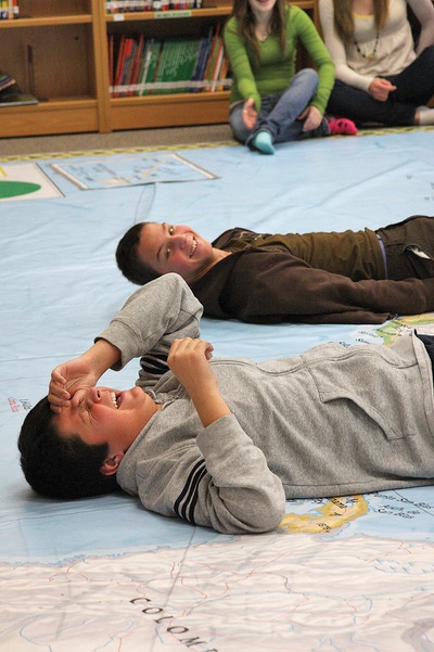
Eighth grader Colton Coss, front, laughs while he and classmate Branislav Klenovski each pose as an isthmus, or a narrow strip of land connecting two larger land areas, on National Geographic's map of North America.
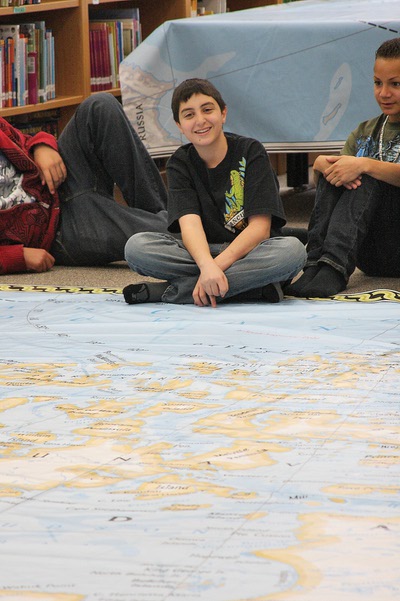
Med Kutob, 13, sits barefoot at the edge of an enlarged map of North America, which his class used to study before mid-terms.
It's not hard to get eighth grade students at Del Webb Middle School interested in learning about North America. All it takes is a gigantic map that covers a good portion of their library.
Shortly after returning to school Jan. 5, that was exactly what the students got, for three days of supervised learning disguised as fun.
Colton Coss, 14, will probably never forget what an isthmus is — a narrow piece of land connecting two larger pieces of land — after he laughed about it for a few minutes Jan. 8, while lying on the giant map and trying to portray an isthmus.
"Remember, it's long and skinny," his teacher, Erik Schindler, said, as Coss struggled for a brief moment trying to figure out how he should position himself.
The maps are loaned to the school by National Geographic.
Herb Thompson, a geography teacher at Webb who works with National Geographic to plan educational events for Nevada students, managed to get the map for a few days because it needed to be cleaned and inventoried before it was shipped to Hawaii. Normally, teachers have to request the maps far in advance.
Last year Asia was at the school for a few days. It threw the teachers off slightly, because students had learned about Asia long before the map's arrival, and they had to adjust the curriculum.
The timing of the map of North America was perfect, students and teachers said. It showed up just before midterms, when students would be tested on much of the information.
"It worked out a lot better," Schindler said. "They have a big test coming up and needed to review. This was a lot more fun."
To teach students about geography, teachers led them through several games, including Simon Says, where they had to place their feet on different landmarks when Simon told them to do so, or the one Coss laughed about, which required various students to actually portray those landmarks, standing as tall as a mountain or lying as flat as an isthmus.
"It was really cool, really helpful," Jordan Gagnon, 14, said. "It helps you understand things, being able to see them larger."
Athena Ibe-Ibanez, 13, said the most helpful thing was the hands-on nature of the map activities. For example, marking the 10 cities with the largest population 100 years ago and 10 cities with the largest population now using orange cones provided a greater visual of how the population has moved west than simply looking at a worksheet.
"The majority of us rely on visuals," Ibe-Ibanez said.
Eighth grader Nathan Cottrell, 13, agreed. Seeing the map and playing the games make a difference in how students learn, he said.
"It helps you understand the features," he said. "It's easier in a fun way."
Thompson said his school may pilot a program next year which would allow him to have the maps for half the school year and loan it out to teachers in the school district. Each teacher interested would need to participate in a workshop Thompson would hold.
Next year's map is Europe, but for the long-term loans, National Geographic may bring out some of the previous year's maps as well, he said.
Frances Vanderploeg can be reached at 990-2660 or [email protected].
Join the Discussion:
Check this out for a full explanation of our conversion to the LiveFyre commenting system and instructions on how to sign up for an account.
Full comments policy