
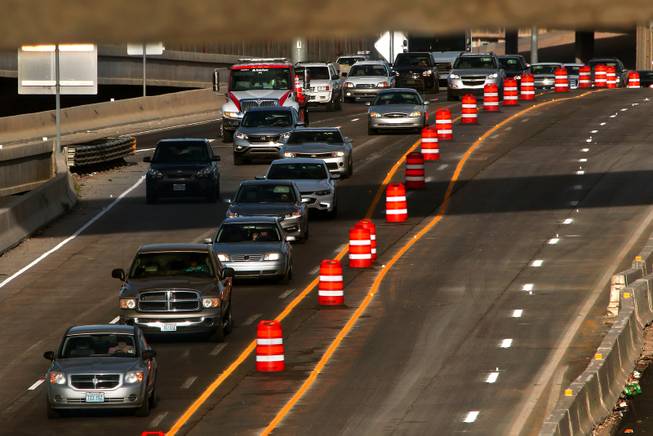
Traffic backs up near a repair project Thursday, Aug. 17, 2017, on northbound Las Vegas Boulevard north of Tropicana Avenue.
Monday, Oct. 30, 2017 | 2 a.m.
Hundreds of cars sit still, quietly humming as they idle in a messy, single-file line flanked by orange traffic cones.
A tractor whizzes by my window going about 5 miles per hour. That’s faster than my Acura has moved in more than 15 minutes.
Driving northbound on U.S. 95 toward the Spaghetti Bowl where it intersects with Interstate 15 has always been a nightmare for residents of Southern Nevada, but lately it’s worse. With all of the construction, bumper-to-bumper traffic during afternoon rush hour has turned the road into a parking lot.
This teeth-grindingly slow journey began around 5 p.m. I jumped on U.S. 95 northbound at Eastern Avenue, the last on-ramp before the bowl. Traffic was free-flowing for about a mile before I hit gridlock. While my lane on the far-left is crawling, at least I’m not in the right lane, where cars are awkwardly trying to merge onto the I-15. They might as well take their keys out of the ignition to save some gas.
Ten minutes after entering the freeway, I’ve traveled about 2.5 miles.
By the time I hit Rancho Drive, traffic opens up. Drivers step on the gas and fly out like doves released at a wedding. I roll my windows down to let the wind hit my face. On the right side, a giant Terrible Herbst sign protrudes over the freeway barrier, the cowboy icon waving goodbye to what I just survived.
In the scheme of things, navigating the Spaghetti Bowl during maximum rush hour in 25 minutes is pretty impressive. But humanity’s hate for traffic isn’t always rational. And a single miscalculation from one of those desperate mergers onto the interstate could have caused a crash and the dreaded chain-reaction of lit taillights all the way to the horizon. — Jesse Granger
Traffic workarounds
• FAST: The Nevada Department of Transportation encourages commuters who want to dodge traffic to utilize the FAST system, covering 600 square miles that include the cities of Las Vegas, Henderson and North Las Vegas — not to mention more than 3,000 traffic signals. Available via text or email (bit.ly/NTv5na), FAST sends alerts when a crash occurs or other events affect traffic.
How does it know? The FAST system monitors traffic flow using data from 600 cameras and a network of pavement, Bluetooth and microwave sensors, providing travel times to 110 destinations on 42 digital messaging signs as well as ramp metering.
FAST also is made possible by a main control room with 20 operators and up to 10 dispatchers from the Nevada Highway Patrol.
“It can send out road crews, manually tweak signal timing and alert the public through a network of dynamic message signs as well as email, text messages, online maps and online images of the roadways,” NDOT spokesman Tony Illia said. “FAST also sends camera feeds to local television stations and the Emergency Operations Center for Southern Nevada, part of the Nevada Highway Patrol Southern Command Headquarters.”
Illia added that all this data-driven coordination can reduce travel time by up to 25 percent.
• Waze: Recommended by both NDOT and RTC, this free, real-time, crowdsourced traffic and navigation app provides motorists alternate routes as they approach backed-up roadways. Drivers anonymously provide intel on slowdowns, and the RTC provides government-reported data on traffic accidents and road construction and closures. The result is a thorough overview of current road conditions.
• Project Neon: This I-15 widening project (between Sahara Avenue and the Spaghetti Bowl interchange) has its own dedicated website — NDOTProjectNeon.com — and social media pages offering updates on construction, so you’ll know where the trouble spots are within the 3.7-mile zone. Or, sign up for the free smartphone/tablet app with live push notifications. Or, call the hotline at 702-293-6366.
• NDOT portals: Motorists can call 511 or visit nvroads.com for the latest highway conditions before beginning their commutes. NDOT also encourages drivers to visit NevadaDOT.com and feeds on Facebook, LinkedIn, Google+, Instagram and Twitter (with the @NevadaDOT handle) for travel and construction info.
MAJOR CHOKEPOINTS

Methodology
The Regional Transportation Commission of Southern Nevada’s Traffic Management Center/FAST (Freeway and Arterial System Transportation) department identified five of the busiest freeway areas and three of the busiest surface streets. All times apply to the Monday-through-Friday window unless otherwise specified.
The sound of horns honking or brakes screeching. The death stares (or unsubtle gestures) from other drivers. This is the fallout when a bunch of humans get stuck. Here are some of the worst bottlenecks in town and road projects aimed at making your commute more sane and civilized.
• 7-8 a.m. and 4-6:30 p.m. on the 215 Beltway northbound between Tropicana and Sahara avenues
• 7-8 a.m. and 4-6:30 p.m. on the 215 Beltway eastbound from Russell Road to Decatur Boulevard
• 7-8 a.m. and 4-6:30 p.m. on the 215 Beltway westbound between I-15 and Durango Drive
Potential solutions: To address backups on and around the 215 Beltway, Clark County has widening projects lined up: the beltway itself (from six lanes to eight) from Tropicana Avenue to the I-15 and surface streets between Pecos Road and Windmill Parkway, said county spokesman Dan Kulin. Both projects will begin in 2018. “The improvements are intended to improve traffic flow in both directions in these areas,” Kulin said. The newly constructed flyover ramp from the airport connector to eastbound 215 has performed well so far, Kulin said. In the northwest, NDOT’s Centennial Bowl project is ongoing. The eastern part of the 215 there was improved to full freeway standards during recent years.
• • •
• 2-6 p.m. on Interstate 15 northbound from Flamingo Road to Charleston Boulevard
• 7-8:30 a.m. and 3-6 p.m. on Interstate 515/U.S. 95 northbound from Boulder Highway to I-15
Potential solutions: A plan to address the congestion is included in NDOT’s I-15 Capacity Improvements Project. It would revamp interchanges and add auxiliary lanes, ramps and turn lanes on I-515 at Boulder Highway, Flamingo Road, Tropicana Avenue and Russell Road.
• • •
• 7-8:30 a.m. on Eastern Avenue northbound between Sunridge Heights Parkway and the 215 Beltway
• 3-6:30 p.m. on Eastern Avenue southbound between Pebble Road and Sunridge Heights Parkway
• Fridays 7-1 a.m. and Saturdays 4 p.m.-2 a.m. on Las Vegas Boulevard between Hacienda Avenue and Convention Center Drive
• • •
Potential solutions for various surface streets: Planned mitigation projects include widening Koval Lane — which many use to get around the Strip — from Sands Avenue to Tropicana Avenue; widening Durango Drive from Windmill Lane to Blue Diamond Road; widening Fort Apache Road from Warm Springs Road to Tropicana Avenue; building a bridge over the railroad tracks to connect Harmon Avenue and Valley View Drive. The widening projects are underway, and construction on the bridge is expected to begin in 2018.
-
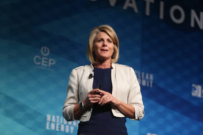
Tina Quigley, general manager of the Regional Transportation Commission of Southern Nevada, speaks during the National Clean Energy Summit 9.0 at the Bellagio on Friday, Oct. 13, 2017.
Q+A: Tina Quigley, general manager of the Regional Transportation Commission of Southern Nevada
Speaking not as a general manager but as a resident who has to get around town, what frustrates you the most about driving?
Orange cones! It drives me absolutely freaking nuts seeing orange cones taking up a lane for a significant amount of time with no construction going on. … Say it’s a three-lane road and you take one lane. You’ve just taken one-third of that capacity. I would love to create policies and programs that would incentivize our contractors to pull back the cones when the lanes aren’t truly under construction.
When it comes to traffic, how does Southern Nevada compare with other densely populated places?
Very clearly, there are some other major metropolitan areas that have congestion that, from a regional perspective, is much worse than ours. But there are pockets of areas where it’s equally bad. Parts of the 215 at certain times of the commute can be very bad. We’re seeing improvements with Project Neon, but prior to that, the Spaghetti Bowl was certainly an area; 95 at that curve out by Summerlin Parkway. … Certainly there are areas where we have considerable congestion. That said, do we rank compared with LA or San Francisco during peak hours? We don’t. But we shouldn’t, because we only have a population of 1 million (drivers). So we’re at a point where it still is manageable; we just need to be managing it responsibly.
Can we really avoid turning into California?
We can look to these other cities for lessons learned after watching them grow. The talent we’ve got in the engineering world (and) the traffic world is cued into what is working nationally and what is not. We know now that just because you add capacity, doesn’t mean you really, truly relieve congestion. In fact, at some point, and there are a lot of examples of this, the more capacity you add, the more congestion you create because the more sprawl you create. ... We know that now, so the approach will be more of “diffuse and disperse,” as opposed to concentrating on a few major arterials or highways.
What are some misconceptions about traffic?
People probably think technology is further along than it is when it comes to managing traffic lights. There will be a lot of exponential advancements ahead, but right now I think people think traffic lights are smarter or should be smarter than they are capable of being. ... Most important, (it’s a misconception) that you can build your way out of congestion. You can’t. You really need to diffuse and disperse the traffic and find alternative routes to destinations.
Do you have any tips on beating traffic?
Use Waze! It will route you around. It will take you the most expeditious route it can find. Sometimes they are routes that you never would have thought of, but they are way faster and avoid congestion. I use Waze religiously. The RTC shares information with Waze — lane closures and construction.
If you could pop into the passenger seat of all the cars stuck in traffic, what would you say to the drivers?
This too shall pass.
— April Corbin
-
Traffic is constricted by lane closures related to Project Neon, a nearly $1 billion, 4-mile-long widening of Interstate 15 from the U.S. 95 interchange to Sahara Avenue on Tuesday, March 21, 2017.
INFRASTRUCTURE FIXES: Construction-caused congestion is the cost of improving our roadways for the future
The great irony of addressing traffic problems is that it often creates them.
Take Project Neon, a massive construction corridor — the largest road project in Nevada’s history — in perhaps the busiest area, the Spaghetti Bowl near downtown. The hassle we feel driving it today is part of the cost of more capacity for the future.
Now 45 percent complete, the project is on schedule to finish in July 2019. The current stage, dubbed “The Big Squeeze,” which is upgrading portions of U.S. 95 near downtown, is scheduled to finish in January, with I-15 improvements to follow.
Last November, a four-lane Western Avenue roadway extension opened, connecting Charleston Boulevard and Grand Central Parkway (Western Avenue previously dead-ended at Holsum Design Center, just south of Charleston Boulevard). The link improved mobility by creating another north-south connection for crosstown traffic.
On Sept. 2, a 1-mile, four-lane Martin Luther King Boulevard alignment opened between Alta Drive and Oakey Boulevard for another major north-south connection into downtown Las Vegas’ Medical and Arts districts.
Crews are building a carpool flyover bridge, redoing a mile of concrete pavement last improved in 1992 and installing Active Traffic Management signs that will help NDOT manage traffic on U.S. 95 and I-15.
The I-15 portion also will play into traffic management for the planned $1.9 billion, 65,000-seat Las Vegas Raiders stadium to be constructed just off the interstate near Russell Road. NDOT estimates it will take about two years to complete, though it depends on which solution is selected. Several actions must be taken before the I-15 improvements can occur. Although NDOT could fast-track a project, decisions still need to be made by the State Transportation Board, and that may affect the delivery schedule.
NDOT has several other projects planned to address traffic growth along the south I-15 corridor, an area that will be heavily affected once the stadium is completed. The projects in the stadium report encompass about eight miles of I-15, between Sahara Avenue and Blue Diamond Road. The department is drafting the scope of work for environmental clearance and preliminary engineering for the I-15 Tropicana Interchange reconstruction and the direct-connect High Occupancy Vehicle ramps proposed at Hacienda and Harmon avenues.
“A request for proposals will be issued in a few months for that scope of work,” NDOT spokesman Tony Illia said. “We hope to advance these projects, which were planned to address traffic growth on the I-15 corridor anticipated to occur in the next 20 years.”
Environmental clearance is the second step, after the planning and engineering feasibility studies performed in 2015 and 2016. Once preliminary engineering is far enough along, NDOT can better estimate the improvement costs. They include further engineering, purchasing right-of-way, relocating utilities, and construction. Eventually, the department will compile a funding plan and get Transportation Board approval to incorporate the projects into its construction program. “The department feels that this new transportation infrastructure can support traffic generated by special events to be held at the proposed stadium on Russell Road,” Illia said. “The improvements were planned to address future traffic growth, but since they add capacity and improve mobility, they can make residents’ and visitors’ trips to the stadium easier.”
NDOT says preliminary studies for these improvements were in the pipeline well before the stadium concept was developed. Freeway improvements would never be the stadium developer’s responsibility anyway, outside of working with Clark County, the RTC and others to determine what is needed to manage stadium traffic. They do have to handle any street projects tied to the stadium build. “The developer would be responsible for constructing road and other infrastructure improvements that are specified in the development agreement,” Clark County spokesman Dan Kulin said. “It is too early to say exactly what those will be.”
— Mick Akers
-
In this Sept. 16, 2014, photo taken with a slow-shutter speed, lights of cars blur along Las Vegas Boulevard.
Strip traffic might surprise you ...
I was running a half-marathon in Florida a few years ago when the leaders of the full marathon came up on my group from the rear. So just for grins, I decided to run with them. By hitting full speed — like, as fast as I’d be running if I were being chased by a guy with an ax — I managed to keep up for about 40 yards with the guy in fifth place.
I’m not a fast runner. But on a recent Friday night, it would have been quicker for me to run from Koval Lane to Las Vegas Boulevard on Flamingo Road than it took me to drive. Way quicker.
I started the timer at 5:46 p.m. when I hit the first backup from Koval. At that point, I was in front of the Tuscany, which, according to geodistance.com, is three-quarters of a mile east of Las Vegas Boulevard. From there to the Strip, it took nearly 13 minutes. My mile time on a bad day is 9.
I waited through two cycles of the light at Koval, three at Linq Lane and two more at Las Vegas Boulevard as traffic inched along. There was no construction, no accident, no traffic stop by police, no clueless tourists trying to change lanes — nothing out of the ordinary. It was just the usual crush of traffic around the Strip.
Do I realize that most Las Vegans would not be caught dead at that place and time unless they were being paid to carry passengers? Of course. But as a Welcome to Fabulous Las Vegas moment, it wouldn’t be fabulous.
You can get lucky, even on the most notorious stretches.
Driving from I-15 through Las Vegas Boulevard on Sahara Avenue at rush hour is hell, right? I’ve been stuck there several times, and when I mentioned to a colleague that I would drive there for this story, he told me he instructs visiting friends and family to avoid it.
But I’m pleased to say that I took four trips there recently — twice on a Thursday evening and twice on a Friday evening — and made it through in a reasonable amount of time. I think the longest I ever waited was three cycles of the light at the boulevard, and from there it was smooth sailing all the way to Eastern Avenue.
The key appeared to be synchronization of the lights east of the boulevard. That allowed traffic to clear out and make way for the next round of cars going eastbound.
Go figure. As is so often the case, Las Vegas refuses to be pigeonholed.
— Ric Anderson


Join the Discussion:
Check this out for a full explanation of our conversion to the LiveFyre commenting system and instructions on how to sign up for an account.
Full comments policy