
Jose Witt
Volunteer Barry Chapman assists with the post-fire recovery efforts at Griffith Peak Trail in 2018.
Sunday, Jan. 26, 2020 | 2 a.m.
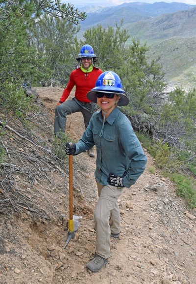
Volunteers Jake Newman and Chelsea Conlin assist with Griffith Peak Trail post-fire recovery efforts in 2018.
When it comes to rebuilding Mount Charleston’s fire-ravaged Griffith Peak Trail, there are no shortcuts.
At 11,060 feet, Griffith Peak is the third-highest summit in the Mount Charleston Wilderness Area. Most of the 5.6-mile trail leading to the mountaintop, known as Griffith Peak Trail, is covered in snow and ice for more than half of the year. Because of its location on a federally protected area, motorized activities are prohibited.
That leaves just one option for volunteers and U.S. Forest Service staff as they work to restore the trail, which was devastated by the 2013 Carpenter 1 Fire: Bearing shovels and other tools, hearty volunteers hike and camp near the trail in the summer months, remove downed trees and other debris, and reconstruct the trail surface with clearly defined boundaries, said volunteer Grace Palermo.
Griffith Peak Trail is the last section of the Spring Mountains National Recreation Area that remains closed to the public six and a half years after the fire, which burned 28,000 acres in the Spring Mountains for seven weeks in summer 2013, said U.S. Forest Service wildlife ecologist Katy Gulley. Led by the group Friends of Nevada Wilderness, 50 to 60 volunteers have so far restored more than half of the trail.
“We were really hoping to get it completed last summer, and then with the late snowmelt, we actually couldn’t get up to the higher camp until late August,” said Palermo, Southern Nevada programs director for Friends of Nevada Wilderness.
Like other post-Carpenter 1 fire recovery efforts, the process of rebuilding the trail isn’t a quick fix. In the summer months, volunteers camp for four days at a time at a base about four miles from the trail. In addition to carrying water, food and camping supplies, they carry tools to remove fire-scorched trees that are obstructing the pathway up the mountain, Palermo said.
Parts of the trail recovery process require more complex work, such as building rock walls to prevent erosion. After the fire destroyed hundreds of trees, whose roots help hold soil in place, massive erosion and subsequent flooding was a major problem, Palermo said.
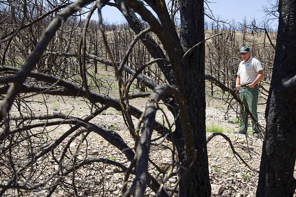
Randy Swick, left, Spring Mountains National Recreation Area manager, looks over burned juniper and pinyon pine trees near Harris Springs Road on Mount Charleston Tuesday, May 27, 2014. The mountain is showing signs of recovery, about one year after the Carpenter 1 Fire that scorched almost 28,000 acres in 2013.
“There were these huge flooding events where soils were removed and the landscape really reshaped itself,” she said.
Most of the remaining Carpenter 1 Fire recovery efforts, including the rebuilding of Griffith Peak Trail, are expected to be completed this year, Gulley said. In addition to restoring the trail, the Forest Service has been fueling tree growth, with the agency having planted 1,160 ponderosa pine saplings near the Cathedral Rock picnic area with the help of 250 volunteers in October, Gulley said.
“We’ve been able to work with partner groups, trying to do replants and transplants and trying to get the trails and the roads fixed,” she said.
More tree plantings are expected to take place in 2020, especially of pinyon pines, juniper, Joshua trees and blackbrush in the Harris Spring Canyon area and again near Cathedral Rock, Gulley said.
“It’s definitely a long-term project,” she said.
Because 853 acres burned at the neighboring Red Rock Canyon National Conservation Area, the Bureau of Land Management is also continuing its fire recovery efforts, said BLM public affairs specialist Kirsten Cannon. The BLM plans to treat invasive weeds that spread after the fire and to monitor ongoing attempts to restore blackbrush this year, Cannon said.
Although the ecosystem is rebounding, the Forest Service will keep monitoring the region even after active recovery efforts end later this year. Perhaps the biggest, immediate threat to the ecosystem’s recovery is illegal off-road vehicle use that triggers new erosional paths in recovering areas, according to Gulley. Hikers also sometimes go off-trail, furthering the same problem, Palermo said.
“That causes a lot of erosion to those areas,” she said.
Later this year, Friends of Nevada Wilderness will organize outreach programs to help hikers and other recreationists understand the importance of staying on trails and not disturbing sensitive areas, Palermo said. The Nevada Conservation Corps also hopes to create new sediment traps to help prevent further erosion, according to Gulley.
Prospective volunteers are welcome to reach out to Friends of Nevada Wilderness or the U.S. Forest Service to help with the last stretch of fire recovery efforts, including spring tree replantings and the rebuilding of the Griffith Peak Trail in the summer.
“Despite being strenuous and a bit of a time commitment, it’s really satisfying to see all of the work we get accomplished up there,” Palermo said.
While the landscape will continue to look altered for the next 100 years, those visiting Mount Charleston later this year might be pleasantly surprised to see fewer charred trees, newly replanted trees and restored wildlife habitats, Gulley said.
“A lot of early species are coming back as expected,” she added.