
Traffic makes its way along the Las Vegas Beltway near the Red Rock hotel-casino in Summerlin on Monday, January 3, 2011.
Published Monday, Jan. 3, 2011 | 7:45 a.m.
Updated Monday, Jan. 3, 2011 | 2:25 p.m.
- Use the hashtag #vegassnow to share your tweets with Las Vegas Sun readers.
Sun weather coverage
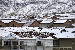
Snow lovers, rejoice. A white blanket of snow coated portions of the Las Vegas Valley this morning, but caused headaches for some motorists in the western valley during their morning commutes.
A winter weather advisory expired at noon today for western and southern Clark County and southern Nye County, according to the National Weather Service. McCarran International Airport reported light snow this morning with temperatures in the mid-30s and 0.01 inch of precipitation. No flight delays were reported as a result of the weather.
Flurries also were reported on the Las Vegas Strip.
In the western valley, snow and ice prompted the closure of the northbound Las Vegas Beltway ramp at Summerlin Parkway this morning, Nevada Highway Patrol Trooper Joseph Fackrell said. It reopened later in the morning.
State Road 160 at Mountain Pass also was closed due to winter conditions that caused several accidents, including one involving an NHP trooper, Fackrell said. The trooper's car was struck and he suffered minor injuries. The highway has since reopened.
At the Red Rock Canyon National Conservation Area, the 13-mile scenic drive was closed this morning due to snow but reopened shortly after 10:30 a.m., the Bureau of Land Management said. The visitor center, Red Spring and the overlook on State Route 159 remained open.
The heaviest snowfall occurred along and west of Interstate 15. The snow moved to the northeast and tapered off in the valley late this morning.
The highway patrol responded to 56 accidents — more than double the amount of a typical day — during a five-hour span in the valley Monday morning as commuters faced the slick roadways, Fackrell said.
Snow accumulations mainly were confined to grassy and desert areas with between 1 and 3 inches, the weather service said. Roads generally saw less than an inch of accumulation but were slushy in some areas.
The second winter storm in less than a week to hit Southern Nevada dumped about 7 inches of snow in Pahrump. Roads in Pahrump were snowpacked, the weather service said.
Snow lovers can thank a low pressure system moving from central California to Southern Nevada for the winter precipitation. Forecasters said snow accumulations of 3 to 7 inches are possible at elevations above 3,500 feet and 8 to 16 inches at elevations above 6,000 feet.
The Mount Charleston Fire Department measured 10 inches of snow at 7 a.m. as light snow continued to fall.
Forecasters expect travel difficulties in certain areas, such as U.S. 95, due to limited visibility and snow-covered roads. The Nevada Highway Patrol already reported several accidents along U.S. 95 in Nye County this morning.
A winter storm warning remains in effect until 4 p.m. today for the Spring Mountains, Sheep Range, Red Rock Canyon National Conservation Area and Mount Charleston.
Mostly cloudy skies will persist today with a 50 percent chance of rain showers after snow moves through and a high near 45 degrees. Temperatures will dip to a low of 33 degrees early Tuesday.
The sun will return Tuesday with the mercury topping out at 48 degrees, followed by highs in the low 50s for the remainder of the week.
Join the Discussion:
Check this out for a full explanation of our conversion to the LiveFyre commenting system and instructions on how to sign up for an account.
Full comments policy