
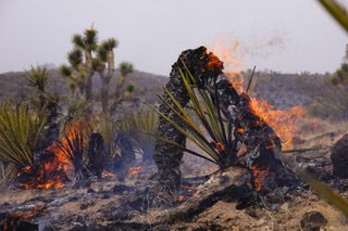
York Fire’s spread heralds the start of persistent wildfire season in Southern Nevada

Destruction left by the York fire in Nipton, California is shown Monday, July 31, 2023.
Wednesday, Aug. 2, 2023 | 2 a.m.
Wildfire season in Southern Nevada remained relatively tame until the York Fire crossed into Nevada from California over the weekend, but the hot, dry weather that paves the way for wildfires might persist into August and beyond, according to the Great Basin Coordination Center.
Shelby Law, a predictive services meteorologist with the Bureau of Land Management, said forecasted rain in Clark County this week wouldn’t be enough to make a meaningful dent in the local fire risk long term. Law said Nevada’s monsoon season had proven drier than usual until rains in the region began Monday and continued into Tuesday.
“This week, we’re looking for a pretty good moisture surge to move through … through Thursday,” she said. “It’s our first significant monsoon push this year; it’s definitely later than normal.”
This year’s fire season in Nevada had been slow to start despite the monsoon’s tardiness, Law said, because of an unusually cool, wet spring that prevented grasses and brush from drying and curing into the kind of fuel that helps produce wildfires.
“Along the California-Nevada border, there’s not a huge difference in vegetation types, so we will often get fires that spread from California to Nevada,” Law said. “But it’s very difficult to predict exactly where a fire is going to start.”
Fire crews in California and Nevada attempted to slow the spread of the fire for a fifth consecutive day Tuesday, and they had to deal with dangerously high temperatures and monsoon-spurred whipping winds, though heavy rain in the afternoon helped to keep the fire controlled. As of 8 p.m. Tuesday, the York Fire was mapped at 80,437 square miles with 23% containment.
The blaze originated Friday near the remote Caruthers Canyon area of the vast wildland preserve. It has sent smoke east into the Las Vegas area.
Although rains Monday and Tuesday were welcome, the precipitation wasn’t expected to have much of an effect on quelling the fire.
“This is a one-week event with that moisture moving through,” Law said. “It does look like things will dry out behind that moisture surge.”
That means there will be a larger supply of dried out vegetation ready to burn in August. Law said that doesn’t mean there would be more fires in late summer, but it meant there was potential for more — especially in Northern Nevada.
“There are some outlooks that are calling for an extended summer into September, possibly into the first part of October, where things might stay on the warmer, drier side,” Law said. “If that’s the case, we could be looking for fires to continue into early fall, which for Nevada, especially along the Sierra front, can be bad.”
Long-term weather forecasts from the National Oceanic and Atmospheric Administration and the National Weather Service’s climate prediction center show potential for hot, dry weather to extend into early fall thanks in part to the warm El Niño climate pattern in the eastern Pacific Ocean.
Strong winds ahead of cold fronts along the Sierra front can spread wildfires through the Reno area. Law said higher elevations in the Sierra front are less at risk because of the historic snowpack they received throughout winter, but mountainside areas with grasses and brush in lower elevations are still at risk.
“It takes a long time for those heavy, big timber forests to dry out,” she said. “And we just don’t think there’s going to be enough time for that to happen this year.”