Courtesy of Southern Nevada Health District
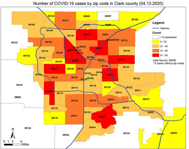
The Southern Nevada Health District has released data on the number of COVID-19 cases in each zip code in Clark County.
Tuesday, April 14, 2020 | 11:15 a.m.
The Southern Nevada Health District has released data on the number of COVID-19 cases in each ZIP code in Clark County.
The ZIP codes with the highest rates of cases – between 61 and 83 – are 89148 and 89117 in southwest Las Vegas, 89052 in Henderson, 89121 and 89110 in east Las Vegas, 89108 in northwest Las Vegas, 89031 and 89030 in North Las Vegas, and 89106 and 89130 in central Las Vegas/North Las Vegas.
As of Monday, 2,509 people in Clark County had tested positive for COVID-19.
Rural communities on the outskirts of the Las Vegas Valley, including ZIP codes in the northern portions of North Las Vegas, Boulder City and the outskirts of the southwest valley, tend to have fewer cases than central valley communities.
The numbers represent raw case numbers and do not account for population density. They also do not reflect the fact that 1,141 people in Clark County – about 45.5% of all COVID-19 patients – have recovered from the disease, and 106 people have died from it.
Another health district map says Las Vegas has had 1,694 cases, North Las Vegas has had 259 cases, Henderson has had 250, Boulder City has had 18 and Mesquite has had five.
All other communities in the Las Vegas Valley, including unincorporated rural areas, have reported fewer than five cases.
The map of cases per city, however, does not correspond perfectly with the boundaries of each jurisdiction, Clark County spokesman Erik Pappa said.
